NCEDC News/Blog
The NCSS now reports earthquake depth relative to the geoid (sea level)
Categories: Northern California Seismic System (NCSS) | Earthquake Depths | Earthquake Catalogue | Catalogs | Earthquake Locations
October 7, 2015
Starting 2015/10/07, the Northern California Seismic System (NCSS) is reporting earthquake depths relative to the earth geoid surface (which is approximately mean sea level) instead of the previously used surface of the velocity model used to locate the events. Geoid depths have been determined for all events in the NCSS database from 1966 to the present. (Learn more about Geoid FAQ) Requests for event information from the NCSS catalog will now return depths with respect to the geoid surface. This change is to comply with recently established USGS Advanced National Seismic Network (ANSS) convention regarding event depth reporting. Additional concurrent changes made to the NCSS earthquake information database are also described below.
 |
|
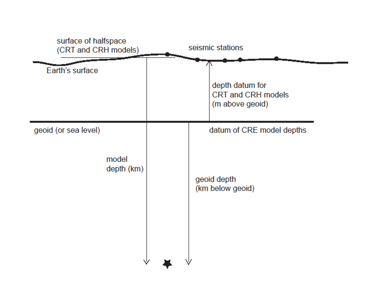
| The offset between the geoid and model depths is the "depth datum." The depth datum is normally the average elevation (above the geoid) of the nearest five stations used to locate the earthquake. Only stations closer than 100 km are used in the average, even if there are fewer than five. Earthquakes for which the nearest station is more than 100 km distant have very poorly determined depths, and the elevation of the nearest station is used as the estimate of the depth datum. Details of the algorithm for determining depth datum, and the handling of model and geoid depths can be found in the hypoinverse manual. For example, deep borehole stations where the sensor is far below the surface are not used in the nearest-five average. Also, the few catalog earthquakes with no station phases cannot be adjusted, and the model and geoid depths are the same. (Click to view larger.) |
To accomplish this transition, an additional step has been added to the location process. The NCSS locates earthquakes with the program hypoinverse using a flat-topped crustal model with linear velocity gradients, referred to as "CRT" layer crustal models. The earthquake depth below this model surface is called the model depth. To determine the geoid depth, the elevation of the flat model surface is inferred from the nearby seismic stations used to locate the event and is subtracted from the model depth. The relationship between model depth and geoid depth is illustrated in Figure 1, taken from the hypoinverse v.1.41 manual (https://ehzftp.wr.usgs.gov/klein/hyp1.41/doc/hyp1.41.pdf, p. 25). Model depth must continue to be used internally in hypoinverse, for purposes such as setting trial or fixed depths. The fundamental location algorithm and multiple crustal models used in the NCSS are unchanged, and the geoid depth adjustment is applied after the earthquake is located. The geoid depth is stored in the database field "depth" in the origin table; the model depth is stored in the field "mdepth."
The model depth is always positive or zero, but the geoid depth can be negative for events above sea level. Catalog searches using depth as a criterion must now use a new minimum negative depth (such as -4 km) to be sure of retrieving all events, including shallow earthquakes in the high Sierras or the Geysers areas. The geoid used for earthquake depths and for station elevations are the same, WGS84.
Networks using hypoellipse "CRE" layer crustal models already calculate geoid depths because both stations and earthquakes are embedded within a layer model that is referred to the geoid. The NCSS will continue to use crustal models with linear gradients ("CRT" models) as there are many benefits. It is very difficult to modify hypoinverse to embed stations in gradient models that allow for shadow zones and interpolating in travel time tables. The NCSS decided it was better to adjust model depths to the geoid rather than attempt calculation of geoid depths directly.
Double-difference depths will also now (eventually) be geoid depths, but DD depths can't be simply adjusted from the model depth. The DD procedure begins with single-event depths from hypoinverse and adjusts locations based on differences between common stations for nearby events. DD locations must be computed from the new geoid depths because the mix of associated events will change once their depths are adjusted to the geoid. We are developing a plan to implement this transition.
New crust model fields were added to the event table in the catalog database that are computed by hypoinverse. These fields are output to hypoinverse format, but are not written to simpler output formats. The crust model fields are not a property of the physical earthquake and are not implemented as search criteria. This involved a schema change to the database.
Additional catalog output for multiple hypoinverse crustal models
The field "crust type " is one letter for the type of hypoinverse crust model, corresponds to the 3rd letter of the hypoinverse command and thus the model type, and is in the database origin table. Currently the NC and BK nets use gradient type T, and CI uses layer type H.
 H - Homogeneous layers, all stations at top (CRH model)
T - Travel time table with linear gradient, stations at top (CRT model)
E - Hypoellipse layer model, using station elevations(CRE model)
L - Hypoellipse single gradient model, using station elevations (CRL)
V - Hypoellipse single gradient over halfspace, using station elevations (CRV)
The field "crust model" is the 3-letter code for the regional crust model. The code is for the "dominant" model because a blend of up to 3 different models can be used for smooth transitions between adjacent models, and the one with the highest weight is saved in this field. In the NCSS, model zones were picked to enclose zones of high seismicity and faults, thus most earthquakes use a single model. Each crust model has its own set of station delays, now in their 4th revision but soon to be in the 5th revision. Many of the crust models are those originally used when individual regions were processed by different research groups, but other models have been added as necessary. The models denoted by east and west are the paired "alternate" models, where one model is used for stations on the east side of the San Andreas fault and the other model for those on the west side. The alternate models are assigned to earthquakes in the same geographic region. The crust model code is in the db origin table. The table is from the shadow2000.doc file used in the NCSS.
Code Name            Source of original model              How derived
AUB  Auburn          Eaton & Simirenko (OFR 80-604, 1980)  test&modify
BAE  Bartlett Spr E  Castillo pers. comm. (1991)             VELEST
BAR  Bartlett Spr Ft Castillo pers. comm. (1991)             VELEST
BAS  Basin & Range   averaged Prodehl (Prof Pap 1034, 1979)  refract
COA  Coalinga        Eaton OFR 85-44 (1985)                test&modify
CON  Concord-Calaveras Klein pers. comm. (1991)              VELEST
COY  Coyote Lake     Reasenberg & Ellsworth (JGR 1982)       VELEST
CST  Central Coast   Poley & Eaton pers. comm.             test&modify
DIA  Diablo-Bear Valley Dietz pers. comm. &                  VELEST
     (west)        Walter & Mooney (BSSA 1982)             refract
GAB  Gabilan-Bear Valley Dietz pers. comm. &                 VELEST
     (east)        Walter & Mooney (BSSA 1982)             refract
GEY  Geysers         Eberhart-Phillips & Oppenheimer JGR ¢84 VELEST
HAY  Hayward Fault   Klein pers. comm. (1990)                VELEST
LAS  Lassen          S. Walter pers. comm.                   VELEST
LEW  Mt. Lewis       Klein pers. comm. (1990)                VELEST
LIV  Livermore-Antioch Klein pers. comm. (1991)              VELEST
LOM  Loma Prieta (west) J. Olsen and M. Zoback (1995)        VELEST
LON  Loma Prieta (east) J. Olsen and M. Zoback (1995)        VELEST
MAA  Maacama Fault   Castillo pers. comm. (1991)             VELEST
MAM  Mammoth Lakes   Kissling (PhD thesis 1986?) &         refract &
                     Cockerham & Kissling pers. comm.      inversion
MAN  Maacama North   Castillo pers. comm. (1991)             VELEST
MEN  Mendocino       Magee pers. comm. (1991)                VELEST
MOR  Morgan Hill     Cockerham & Eaton
                     (USGS Bulletin 1639, 1987)              VELEST
NBY  North SF Bay Eberhart-Phillips & Oppenheimer (JGR 1984) VELEST
NCG  N. Calif gradient default model derived from
                     Eaton pers. comm.                    test&modify
PEN  SF Peninsula north Olson (Proc. Rec. Crus. Mvmts. 1987?) VELEST
PES  SF Peninsula south Olson (Proc. Rec. Crus. Mvmts. 1987?) VELEST
PGH  Park.-Gold Hill Poley & Eaton pers. comm.            test&modify
PMM  Park.-Middle Mtn. same as PGH.                       test&modify
PSM  Park.-Simmler   same as PGH                          test&modify
PTA  Pt Arena, Ft Bragg Castillo pers. comm. (1991)           VELEST
SCA  Southern Calif. Jones pers. comm.                       refract?
SHA  Shasta & Oregon average from Zucca et al. (JGR 1986)    refract
SIM  San Simeon & central coast Klein pers. Comm.             VELEST
TRA  Transverse Ranges Prodehl PP-1034 (1979)                refract
TRE  Tres Pinos      Dietz pers. comm. &                      VELEST
                     Walter & Mooney (BSSA 1982)             refract
WAL  Walker Pass     Jones & Dollar (BSSA 1986)           test&modify
NCEDC News
-
: Entire NCEDC Dataset Now Available Through AWS
-
: Current issue with ObsPy FDSN web service client
-
: FTP service to be retired on May 31, 2022
Categories
- 2003 San Simeon Earthquake (5)
- 2004 Parkfield Earthquake (3)
- Berkeley Digital Seismic Network (BDSN, BK) (11)
- Bugs (6)
- Calpine/LBL Geysers data (BG) (8)
- Catalogs (21)
- Data Access Methods (19)
- Data Availability (32)
- Data Center Operations (26)
- Data Center Outages (9)
- Data Distribution (3)
- Data Holdings (16)
- Earthquake Catalogue (21)
- Earthquake Depths (3)
- Earthquake Locations (9)
- High Resolution Seismic Network (HRSN, BP) (4)
- Magnitude (10)
- Magnitude Errors (4)
- Metadata (4)
- Northern California Earthquake Data Center (NCEDC) (14)
- Northern California Seismic System (NCSS) (7)
- Northern Hayward Fault Network (NHFN, BK) (3)
- SEED format (6)
- Sampling Rate (3)
- Strain Data (3)
- The Geysers (5)
- Timing Errors (3)
- U.S. Geological Survey (USGS) (3)
- UC Berkeley Seismological Laboratory (BSL) (4)
- USGS Northern California Seismic Network (NCSN) (11)
- Uncategorized (4)
- Waveform Data (33)
- Web Services (5)